|
Russel Wallace : Alfred Russell Wallace (sic)
The most striking characteristic of the Rio Negro is that from which it derives its name--its black waters. And this is no imaginative or fanciful appellation; forasmuch as the waters of the ocean are blue, so are those of this river jet black. The sudden change from the pale-yellowish olive of the Amazon is most striking, and must have immediately suggested its name to its [[p. 213]] first European discoverers. The water, when examined in a glass vessel, is seen to be very slightly tinged with a clear coffee brown; and where it runs over white sand, at the depth of a few feet, it appears of a rich golden brown colour. In deep water it is, in every variety of light, jet black. The colour varies in intensity in different parts of its course. In the lower part there is a slight olive tint, caused by a mixture of sediment; higher up in the rocky district it is much purer and more transparent, and towards its sources above the falls, and in its smaller branches, the water attains its maximum of purity and colour. The tributary streams vary much in this particular. All on its southern side, above those which communicate with the Solimões, are black, the great river Uaupés alone being of a rather paler colour, though it, too, is a black-water river. On the N. side, also, there are some black-water streams, though the greater number are white. The small streams below the Rio Branco are black. That river, however, is white to a remarkable degree, its waters being actually milky in appearance. Above it, the Darahá and some other small streams are black, while the Padauarí, Maravihá, and Cababurís are white-water rivers, though none of them so much so as the Rio Branco, or even as the Amazons. Other small streams flowing between them have black water. These various-coloured waters may, we believe, readily be accounted for by the nature of the country the stream flows through. The fact that the most purely black-water rivers flow through districts of dense forest, and have granite beds, seems to show that it is the percolation of the water through decaying vegetable matter which gives it its peculiar colour. Should the stream, however, flow through any extent of alluvial country, or through any districts where it can gather much light-coloured sedimentary matter, it will change its aspect, and we shall have the phenomenon of alternating white and black water rivers. The Rio Branco and most of its tributaries rise in an open, rocky country, and the water there is pure and uncoloured; it must, therefore, be in the lower part of its course that it obtains the sediment that gives it so remarkably light a colour; and it is worthy of note, that all the other white-water tributaries of the Rio Negro run parallel to the Rio Branco, and, therefore, probably obtain their sediment from a continuation of the same deposits; only as they flow entirely through a forest district producing brown water, the result is not such a strikingly light tint as in the case of that river. The Isánna, Xíe, and Guaniá or Upper Rio Negro, which all have remarkably black waters, we know flow entirely through a dense forest and granitic district, and none of them extend much beyond the parallel of 72° W. of Greenwich. The Guaviare and
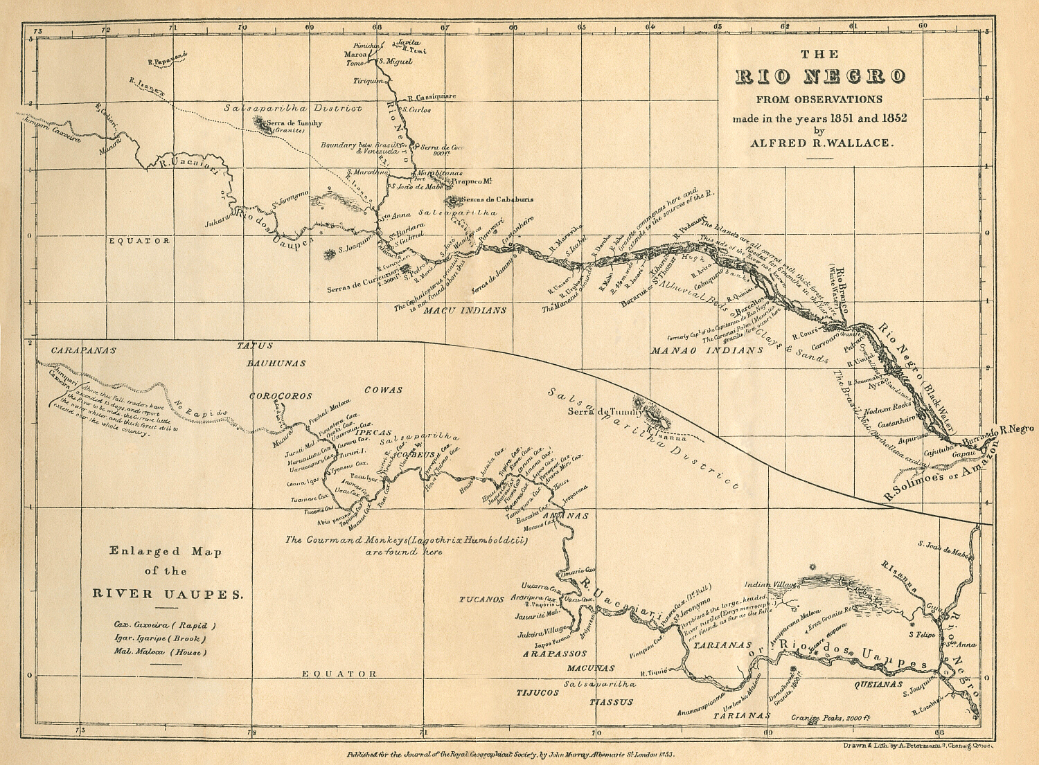
[[p. 214]] the Japurá, which rise considerably W. of this line, have white waters; and the Uaupés, which also rises near them, and much further W. than all the other tributaries of the Rio Negro, has also paler waters, and in its upper course nearly white. On ascending the Rio Negro, at about 10 miles from its mouth, we reach the city of Manao, or Barra do Rio Negro, the capital of the new province of Amazonas. At 40 miles the river divides into two branches, and from this point to the mouth of the Rio Branco, at about 200 miles up, the N. bank is never to be seen from the S. side, up which all the traffic takes place. The river is here more like an immense lake or labyrinth of islands, and is 15 or perhaps 20 miles wide. For about 70 miles below the village of Ayrão there are high banks of clay and sandstone; below and above this are tracts of low, flooded lands, and between Ayrão and the next village, Pedreiro, are two channels which communicate with the Solimões, or Upper Amazon. Below Ayrão commences a hard sandstone rock; about Pedreiro it becomes highly crystalline, and a little further, opposite the Rio Branco, it changes into a true granitic rock, which, however, immediately ceases, and does not again appear until we arrive at the commencement of the great granitic district of the Upper Rio Negro. Immediately on passing the Rio Branco, islands again appear, and the opposite bank is not visible for 240 miles further, when in about 64° 20' W. the river is clear, and its width, determined by triangulation from a measured base, is 4 1/4 miles. In this space we have passed the towns of Carvoeiro, Barcéllos, Cabuquéno, and Bararuá, which are all of them small, half-ruined, and almost uninhabited villages. About Carvoeiro is a labyrinth of lakes and islands in which even experienced pilots are sometimes lost. From the river Qúiuiní to Xibarú are high banks of clays and earth of various colours, with occasional inlets, lakes, and tracts of flooded lands. All the islands, as well as the low parts of the river banks, are flooded annually for several months--generally from April to August or September, the rise of the river being from 30 to 50 feet. In 64° 25' W. long., the granitic formation commences, and extends without interruption up to the sources of the river and of all its tributaries. From this point there is less flooded land on the banks, and some islands are always above water. Islands still continue in great abundance up to Castanheiro. From thence to the cataracts of St. Gabriel they are more rocky, and smaller. The river averages 3 or 4 miles wide, and up towards the falls one mile. A little below Castanheiro begin the isolated granite peaks, which are thence plentiful all up the river. The Serra de Jacamí [[p. 215]] is the first of any size--a group of isolated, conical, granite hills, 500 or 600 feet high. About 20 miles below S. Gabriel are the Serras de Curicuriarí, which must be nearly 3000 feet high, and are the most lofty in the whole district, though the Serras de Cababurís, near the sources of the river Cababurís are perhaps nearly equal to them. The cataracts of the Rio Negro extend in length about 20 miles, and are a series of rapids, where the river flows among islands and vast masses of granite rock, forming falls, eddies, and whirlpools, which greatly obstruct navigation. They may be descended in a few hours with a skilful pilot, but a laden canoe often takes a week to ascend them, and at some seasons more; and then with great peril both to life and property. Above the falls the river keeps an average width of about 3/4 mile to S. Carlos, the first town in the Republic of Venezuela. Above the Cassiquiare the Rio Negro takes the name of the Guainiá, and gets narrower and more shallow, varying from 1/4 to ½ a mile wide up to Maróa, the last village on the river. Above this it winds about, turning to the W., and has its sources certainly to the eastward of the meridian of 71° W. longitude, and probably near that of 70°. The Uaupés is the largest tributary of the Rio Negro above the falls, and is perhaps larger than the Rio Negro itself; and by some is supposed to be the principal stream. We ascend it for about 130 miles in smooth water, when we come to the first group of cataracts, just above the village of St. Jeronymo. There are three falls, and they are much more furious and dangerous than those of the Rio Negro, the river being confined in a very narrow channel, and in the wet season rushing down with incredible fury. Up to this point the Uaupés is generally more than a mile wide. Above these falls we have about 50 miles more of smooth water, when with the next fall begins a series of cataracts extending for 180 miles further up the river. They are placed in four principal groups, and there are 50 of them which have native names. Some of these are mere rapids, others foaming cataracts, and others again real falls of 10 or 15 feet perpendicular height. Above these, the river is quite unknown. One more great fall, the Jurupari Caxoeira, exists, at least 100 miles further up; and above this again traders have ascended for 12 or 15 days, and report a great river with little current, with whiter water, and with trees, birds, and fishes, which assimilate it to the Upper Amazon. The mean temperature of the water of the Rio Negro in its lower part, in the month of September, was, at 6 A.M., 85° 4' [85.4?--Ed.]; at 2 P.M., 86° 5'; and at 6 P.M., 86° 4'; giving very nearly 86° as the mean temperature for the month, which is one of the hottest in the year. The mean temperature of the air for the same period [[p. 216]] was, at 6 A.M., 76°; and at 2 P.M., 92° 5'. It is probable that at no time would the temperature of the water in the lower part of the Rio Negro be less than 80°. The rise of country in the valley of the Rio Negro is remarkably slight. Humboldt gives the height of St. Carlos as 812 feet above the sea; but I have reason to believe it is much less. Observations of the boiling point of water made at the mouth of the Rio Negro, and at different points up to near St. Carlos, gave me a rise of about 300 feet. The height of the mouth of the Rio Negro cannot be more than 200 feet, and probably not more than 150, judging from the height of Tabatinga, 1000 miles higher up the river, given by Martins as 620 feet; and from the fact of the influence of the tides being felt at Obydos, more than half-way from the ocean to the mouth of the Rio Negro. We should, therefore, have 400 to 500 feet for the height of St. Carlos, which I cannot but think is not far from the truth. It is to be observed that Humboldt mentions air having got into his barometer-tube, which rendered refilling necessary, and of course destroyed the trustworthiness of the instrument. It is a remarkable fact, that the pressure of the atmosphere at the mouth of the Rio Negro, as observed by the boiling-point of water, and by an aneroid, in the possession of my friend Mr. Spruce, was greater than at Pará at the level of the sea, giving a negative result for the altitude. It, therefore, seems probable that there is a difference of atmospheric pressure in the interior of South America independent of altitude. Having unfortunately broken my thermometers, I had no means of ascertaining the height I reached on the Uaupés; but from an estimate of the depth of the falls, I do not think my farthest point could be more than 1000 feet above the sea-level. The whole of the country through which the Rio Negro and Uaupés flow is one unbroken forest, which also extends over every one of the countless islands which are found in every part of its course. The numerous villages, whose names are marked on our maps, are little groups of mud-walled, palm-thatched cottages; and it seldom happens that more than two or three in a village are inhabited, the Indians preferring to reside in houses secluded in the forest, up the various narrow streams that everywhere abound. The articles of export of the country are chiefly salsaparilha and piassába. The latter is the material used to make the brooms now used for sweeping our streets, and is the produce of a palm found only on some of the tributaries of the Rio Negro. The inhabitants of the banks of the main stream of the river are semi-civilized, and are nominal Christians; but most of the tributary streams, and especially the Uaupés, are inhabited by various tribes of uncivilized and unchristianized Indians. [[p. 217]] The map which I have constructed of the Rio Negro and the Uaupés is from observations made during two ascents and descents of those rivers in the years 1850, 1851, and 1852. The only instruments I possessed were a prismatic compass, a pocket sextant, and a watch. With the former I took bearings of every point and island visible on my voyage, with sketches, embodying all the information I could obtain from the persons, well acquainted with the river, who accompanied me; and I constantly determined the variation of the needle, which was from 4 3/4° to 5° E. With the sextant I was enabled to obtain a few latitudes with tolerable accuracy. The position of Barra on the Rio Negro I have taken from Lieut. Smith, who determined it on his descent of the Amazon in the year 1835. The other extreme point, S. Carlos and the mouth of the Cassiquiare, I have taken from Humboldt and Schomburgk. For my positions between these points I have had to trust to the time occupied in the passage to the various stations, which I always accurately noted both in my ascents and descents, and thus obtained a mean which I think will not be very far from the truth. I also thus gained experience as to the rate of travelling in canoes under different circumstances, which I have had to depend upon in determining my distances on the Uaupés, where I had no other method of ascertaining the longitude of the extreme point reached. The map, therefore, does not pretend to any minute accuracy in general positions, but only to give an idea of the physical features of a river still very imperfectly known. The following are the most important distances on the Rio Negro:-- From its mouth to the falls of São Gabriel . . . . . . . . . . . . . . . . . . . . 710 miles.
|