|
Russel Wallace : Alfred Russell Wallace (sic) Erosion of Lake Basins. (S481: 1893)
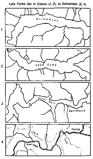
This question of the origin of the lake-basins of the glaciated regions is especially interesting on account of the extreme divergence of opinion that still prevails on the subject. While the general facts of glaciation, the extent and thickness of the old glaciers and ice-sheets, and the work they did in distributing huge erratics many hundred miles from their sources and in covering thousands of square miles of country with thick layers of boulder-clay and drift, are all admitted as beyond dispute, geologists are still divided into two hostile camps when the origin of lake-basins is concerned; and the opposing forces seem to be approximately equal. Having for many years given much attention to this problem, which has had for me a kind of fascination, I am convinced that the evidence in favour of glaciation has not been set forth in all its cumulative force, while many of the arguments against it seem to me to be either illogical or beside the point at issue. I have also to adduce certain considerations which have hitherto been overlooked, but which appear to me to afford very strong, if not conclusive evidence for erosion as against any alternative theory yet proposed. I shall, therefore, first set forth, as fully as the space at my command will allow, the [[p. 751]] general evidence in favour of the ice-origin of certain classes of lakes, and the special conditions requisite for the production of lakes by this agency. The objections of the best authorities will then be considered and replied to, and the extreme difficulties of the alternative theories will be pointed out. I shall then describe certain peculiarities, hitherto unnoticed, which clearly point to erosion, as opposed to any form of subsidence and upheaval, in the formation of the lakes in question. Lastly, the special case of the Lake of Geneva will be discussed, as affording a battle-ground that will be admitted to be highly favourable to the anti-glacialists, since most of them have adduced it as being entirely beyond the powers of the ancient glaciers to have produced. 1. The different kinds of Lakes and their distribution.--To clear the ground at the outset, it may be well to state that the great plateau lakes of various parts of the world have no doubt been formed by some kind of earth movements occurring subsequent to the upheaval and partial denudation of the country. It is universally admitted that existing lakes cannot be very ancient, geologically speaking, since they would inevitably be filled up by the sediment carried into them by the streams and by the wind. Our lakes must, therefore, be quite modern features of the earth's surface. A considerable proportion of these plateau lakes are in regions of little rainfall, and many of them have no outlet. The latter circumstance is a consequence of the former, since it indicates that evaporation balances the inflow. This would have favoured the formation of such lakes, since it would have prevented the overflow of the water from the slight hollow first formed, and the cutting of an outlet gorge which would empty the incipient lake. Captain Dutton, in his account of the geology of the Grand Cañon district, lays stress on this fact, "that the elevation of a platform across the track of a river rarely diverts it from its course, for the stream saws its bed into the rocks as fast as the obstacle rises." Scanty rainfall and great evaporation seem therefore to be almost essential to the formation of the larger plateau lakes. Rarely, such lakes may have been formed in comparatively well-watered districts, but the earth-movements must in these cases have been exceptionally rapid and extensive, and they are accordingly found most often in countries subject to volcanic disturbances. Such are the lakes of Southern Italy, of Macedonia, of Asia Minor, and perhaps those of Central Africa. Quite distinct from these are the sub-alpine lakes of those mountain groups which have been subject to extreme glaciation. These are characteristically valley-lakes, occurring in the lower portions of the valleys which have been the beds of enormous glaciers, their frequency, their size, and their depth bearing some relation to the form and slope of the valleys and the intensity of the glaciation to [[p. 752]] which they have been subject. In our own country we have in Wales a small number of valley-lakes; in the Lake District, where the ice-sheet can be proved to have been much thicker and to have lasted longer, we have more numerous, larger, and deeper lakes; and in Scotland, still more severely glaciated, the lakes are yet more numerous, many of those in the west opening out to the sea and forming the lochs and sounds of the Western Highlands. Coming to Switzerland, which, as we have seen, bears indications of glaciation on a most gigantic scale, we find a grand series of valley-lakes both on the north and south, situated for the most part in the tracks of those enormous glaciers whose former existence and great development is clearly proved by the vast moraines of Northern Italy and the travelled blocks of Switzerland and France. In Scandinavia, where the ice-age reigned longest and with greatest power, lakes abound in almost all the valleys of the eastern slope, while on the west the fiords or submerged lakes are equally characteristic. In North America, to the south of the St. Lawrence River and of Lakes Ontario and Erie, there are numbers of true valley-lakes, as there are also in Canada, besides innumerable others scattered over the open country, especially in the north, where the ice-sheet must have been thickest and have lingered longest. And in the southern hemisphere we have, in New Zealand, a reproduction of these phenomena--a grand mountain-range with existing glaciers, indications that these glaciers were recently much more extensive, a series of fine valley-lakes forming a true lake district, rivalling that of Switzerland in extent and beauty, with fiords on the south-west coast comparable with those of Norway. Besides these valley-lakes there are two other kinds of lakes always found in strongly glaciated regions. These are alpine tarns--small lakes occurring at high elevations and very often at the heads of valleys under lofty precipices; and small or large plateau or low-level lakes which occur literally by thousands in Northern Canada, in Sweden, Finland, Lapland, and North-western Russia. The valley-lakes and the alpine tarns are admitted by all geologists to be mostly true rock-basins, while the plateau and low-country lakes are many of them hollows in the drift with which much of the country is covered, though rock-basins are also not unfrequent. Here, then, we see a remarkable association of lakes of various kinds with highly glaciated regions. The question is whether there is any relation of cause and effect in the association; and to determine this we must take a rapid survey of other mountain regions where indications of ice-action are comparatively slight or altogether wanting, and see whether similar lakes occur there also. The comparison will, I think, prove very instructive. Spain and Portugal are pre-eminently mountainous countries, [[p. 753]] there being a succession of distinct ranges and isolated mountain groups from east to west and from north to south; yet there is not a single valley-lake in the whole peninsula, and but very few mountain tarns. Sardinia and Corsica are wholly mountainous, but they do not appear to possess a single valley-lake. Nor does the whole range of the Apennines, though there are many large plateau lakes in Southern Italy. Farther south we have the lofty Atlas Mountains, but giving rise to no subalpine valley-lakes. The innumerable mountains and valleys of Asia Minor have no lakes but those of the plateaux; neither has the grand range of the Lebanon, a hundred miles long, and giving rise to an abundance of rivers. Turning to the peninsula of India we have the ranges of the Ghats, eight hundred miles long, the mountain mass of the Neilgherries and that of Ceylon, all without such lakes as we are seeking, though Ceylon has a few plateau lakes in the north. The same phenomenon meets us in South Africa and Madagascar--abundance of mountains and rivers, but no valley-lakes. In Australia, again, the whole great range of mountains from the uplands of Victoria, through New South Wales and Queensland to the peninsula of Cape York, has not a single true valley-lake. Turning now to the New World, we find no valley-lakes in the southern Alleghanies, while the grand mountains of Mexico and Central America have a few plateau lakes, but none of the class we are seeking. The extremely mountainous islands of the West Indies--Cuba, Hayti, and Jamaica--are equally deficient. In South America we have on the east the two great mountain systems of Guiana and Brazil, furrowed with valleys and rich in mountain streams, but none of these are adorned with lakes. And, lastly, the grand ranges of the equatorial Andes, for ten degrees on each side of the Equator, produce only a few small lakes on the high plateaux, and a few in the great lowland river plains--probably the sites of old river channels--but no valley-lakes in any way comparable with those of Switzerland or even of our own insignificant mountains. Having thus roughly surveyed the chief mountain regions of the whole world, we find that true subalpine valley-lakes, that is, lakes in the lower parts of the valleys descending from mountain ranges or groups, filling up those valleys for a considerable distance, usually very deep, and situated in true rock-basins--that such lakes as these are absolutely unknown anywhere but in those mountain regions which independent evidence shows to have been subject to enormous and long-continued glaciation. No writer that I am acquainted with has laid sufficient stress on this really marvellous fact of lake-distribution. Professor Bonney passes it by with the remark, that there is a perfect gradation of lakes, from the smallest tarns to those of North America and Central Africa; and Mr. [[p. 754]] Douglas Freshfield says, that, wherever on the surface of our globe there are heights there must be hollows; and other writers think that lakes are general results of the process of mountain-making. But none of these writers have apparently even noticed the fact, that glacier valley-lakes have a distinctive character which separates them broadly from the lakes of all non-glaciated countries, and that they are totally absent from such countries. But besides the mountains which possess true valley-lakes, there are a number of ranges which have been glaciated yet do not possess them, and this absence of lakes has been used as an argument against the connection of valley-lakes with glaciation. A little examination, however, shows us that these cases greatly strengthen our argument. Comparatively large and deep valley-lakes are the result of excessive glaciation, which has occurred only when conditions of latitude, altitude, and moisture combined to produce it. In regions where glaciation was of diminished intensity, from whatever causes, valley-lakes diminish in size and number, till at last only tarns are found in moderately glaciated districts. Thus, the Pyrenees were far less severely glaciated than the Alps; they consequently possess no large valley-lakes, but numerous small high lakes and tarns. As we go eastward in the Alps, the diminished rain and snow-fall led to less severe glaciation, and we find the valley lakes diminish in size and numbers till far east we have only tarns. The Carpathians have no valley-lakes, but many tarns. The Caucasus has no lakes, and very few tarns, and this may be partly due to the steepness of the valleys, a feature which is, as we shall see, unfavourable to lake formation. In the South Island of New Zealand the lakes are small in the north, but increase in size and number as we go south where the glaciation was more intense. These numerous facts, derived from a survey of the chief mountains of the world, are amply sufficient to show that there must be some causal connection between glaciation and these special types of lakes. What the connection is we shall inquire later on. 2. The conditions that favour the production of Lakes by Ice-erosion.--Those who oppose the production of lake basins by ice-erosion often argue as if the size of the glacier was the only factor, and urge that, because there are no lake-basins in one valley where large glaciers have been at work, those which exist in another valley where the glaciers were no larger, could not have been produced by them. But this by no means follows, because the production of a lake-basin depends on a combination of favourable conditions. In the first place it is evident that ice-erosion to some extent must have taken place along the whole length of the glacier's course, and that in many cases the result might be simply to deepen the valley all along, not quite equally, perhaps, but with no such extreme differences as [[p. 755]] to produce a lake-basin. This would especially be the case if a valley had a considerable downward slope, and was not very unequal in width or in the nature of the rocks forming its floor. The first essential to lake-erosion is, therefore, a differential action, caused locally either by increased thickness of the ice, a more open and level valley-floor, or a more easily eroded rock, or by any combination of these. If we look at the valley-lakes of our own country and of Switzerland, the first thing that strikes us is their great length, and their situation, usually at the lower end of the valley where it emerges from the higher mountains into comparatively low country. Windermere is over ten miles long, Ullswater nearly eight miles, and the larger lakes of Switzerland and North Italy are very much longer. The first essential condition, therefore, was a valley, the lower part of which was already nearly level for several miles, and with a considerable width to the base of the mountain slopes. In the non-glaciated districts of our own country, the Dart and the Tamar are examples of rivers which have cut their valleys down nearly to sea-level while still among the hills; and in South Wales the Wye, the Usk, and the Severn have a similar character. It must always be remembered that glacial erosion is produced by the tremendous vertical pressure of the ice, by its lower strata being thickly loaded with hard rocks frozen into its mass, and by its slow but continuous motion. In the lower part of its course a glacier would be most charged with rocky débris in its under strata, since not only would it have been continually breaking off and absorbing, as it were, fresh material during every mile of its onward course, but more and more of its superficial moraines would be engulphed by crevasses or moulins, and be added to the grinding material below. That this was so is proved by the great quantity of stones and grit in the "till," which is thought by Professor James Geikie to consist, on the average, of as much stony matter as clay, sometimes one material preponderating, sometimes the other. The same thing is indicated by the enormous amount of débris often found on the lower parts of large glaciers. The end of the great Tasman glacier in New Zealand is thus completely hidden for five miles, and most of the other glaciers descending from Mount Cook have their extremities similarly buried in débris. Dr. Diener found the Milam glacier in the Central Himalayas completely covered with moraine rubbish; and Mr. W. M. Conway states that the lowest twenty miles of the Hispar glacier (forty miles long) are "entirely covered with a mantle of moraine." If these glaciers extended to over a hundred miles long, as did the Rhone glacier when it reached the Lake of Geneva, much of this débris would probably have found its way to the bottom, and thus supply the necessary grinding material and the abundant stones of the "till" found everywhere in the tracks of the old glaciers. [[p. 756]] Again, although ice is viscous and can slowly change its shape to almost any extent, yet it takes a considerable time to adapt itself to continually changing outlines of the valley bottom. Hence, where great inequalities occur portions of the rocky floor might be bridged over for a considerable space, and where a valley had a narrow V-shaped bottom the sub-glacial stream might eat away so much of the ice that the glacier might rest wholly on the lateral slopes, and hardly touch the bottom at all. On a tolerably wide and level valley bottom, however, the ice would press with its fullest intensity, and its armature of densely packed stones and rock-fragments would groove and grind the rocky floor over every foot of its surface, and with a rate of motion perhaps greater than that of the existing Greenland and Alaskan glaciers, owing to the more southern latitude and therefore higher mean temperature of the soil and the ice. At the same time sub-glacial streams, forced onward under great hydrostatic pressure, would insinuate themselves into every vacant groove and furrow as each graving tool successively passed on and the one behind it took a slightly different position; and thus the glacial mud, the product of the erosion, would be continually washed away, finally escaping at the lower extremity of the glacier, or in some cases getting embayed in rocky hollows where it might remain permanently as masses of clayey "till," packed with stones and compressed by the weight of the ice to the hardness of rock itself. The continual lubrication of the whole valley floor by water forced onward under pressure, together with the ever-changing form of the under surface of the glacier as it slowly moulded itself to the varying contours of the rocks beneath, would greatly facilitate the onward motion. Owing to these changes of form and the great upward pressure of the water in all the hollows to which it gained access, it seems probable that at any one time not more than half the entire bottom surface of the glacier would be in actual contact with the rock, thus greatly reducing the friction; while, as the process of erosion went on, the rock surfaces would become continually smoother and the inequalities less pronounced, so that even when a rock-basin had been ground out to a considerable depth the onward motion might be almost as great as at the beginning of the process. If, now, we consider that the erosion I have attempted to describe was going on during a large part of the glacial period, under a weight of ice varying from one to three or four thousand feet in thickness; that the huge grinding tool was at work day and night, winter and summer, century after century, for whatever number of thousands of years we give to the glacial period; that--as innumerable other facts prove--the ice moved irresistibly over hill and dale, [[p. 757]] and up slopes far steeper than any formed by the upward slopes of the bottom of our deepest lakes, what is there of impossible, or even of improbable in the belief, that lake-basins were produced by such differential erosion? To the ordinary observer it seems impossible that a mountain valley, half a mile wide and bounded by rocky slopes and precipices two or three thousand feet high, can have been formed without any "convulsion of nature," but merely by the natural agencies he sees still in action--rain and frost, sun and wind--and that the small rock-encumbered stream now flowing along its bottom can have carried away the whole of the cubic miles of solid rock that once filled up the valley. But the geologist knows that these apparently insignificant forces have done the work, through their continuous action always in one direction for thousands, or even for millions, of years; and, therefore, having before him so many proofs of the eroding power of ice, in planed and rounded rocks, and in the grooves and furrows which are the latest marks left by the ice-tool, and bearing in mind the long duration and possibly recurrent phases of the ice age--to be measured certainly by tens, perhaps by hundreds, of thousands of years--he can have little difficulty in accepting the erosion of lake-basins as the most satisfactory explanation of their origin. 3. Objections of modern writers considered.--Professor Bonney and many other writers ask, why lakes are so few though all the chief valleys of the Alps were filled with ice; and why, for instance, there is no great lake in the Dora Baltea valley whose glacier produced the great moraines of Ivrea opposite its outlet into the plains of Italy, and which form a chain of hills fifteen miles long and fifteen hundred feet high? The answer, in the case of the Dora Baltea, is not difficult, since it almost certainly has had a series of lake-basins at Aosta, Verrex, and other places where the broad level valley is now filled with alluvial gravel. But the more important point is the extreme narrowness of the lower part of the valley above Donnas and again near its entrance into the valley of the Po. The effect of this would be that the great glacier, probably two thousand feet thick or more, would move rapidly in its upper layers, carrying out its load of stones and débris to form the terminal moraine, while the lower strata, choked in the defiles, would move very slowly. And once out in the open valley of the Po, then a great inlet of the warm Mediterranean Sea, the ice would rapidly melt away in the water and in the warm moist atmosphere, and therefore have no tendency to erode a lake basin. The Lake of Lugano, with its curious radiating arms, is said to be another difficulty. But each of these arms is the outlet of a valley or series of valleys, which were no doubt reduced to nearly level [[p. 758]] plains by sub-aerial denudation before the ice began its work. The basin of these valleys comprises about two hundred square miles and the watershed to the north is moderately high; but there can be no doubt that a large overflow from the Como glacier poured into it; and the difficulty seems to me to be purely imaginary if we simply recognise the fact that an essential preliminary to lake-erosion is a pre-existing nearly level valley bottom. Another difficulty is said to be the frequent presence of islands in the lakes: but here again the answer is easy. The islands, always ground down to roches moutonnées, were craggy hills in the pre-existing valleys, and such hills existed because they had for ages resisted the sub-aerial denudation which had hollowed out the valleys. The same characters of density or toughness that enabled them to resist ordinary denudation, enabled them also, to some extent, to resist destruction by ice-erosion; just as the character of the rocks which enabled ordinary denudation to bring them down to a nearly level surface in the valley-bottom, also facilitated the ice-erosion which converted the level valley floor into a rock-basin, and after the ice left it into a lake. Every writer brings forward the well-known fact that the ends of glaciers pass over beds of gravel or moraine matter, without destroying or even disturbing it. But there is no reason why they should do more than compress such beds of loose material and roughly level their surfaces. It is the old delusion of a glacier acting like a scoop or a plough that leads to the idea that if it can erode rock slowly it must altogether demolish gravel or boulder clay. But if we turn to the description I have given of how a glacier erodes a rock-basin and apply this to its passage over a bed of gravel or boulder clay, we shall see that in the latter case the erosion would be much more difficult, because each ice-embedded stone or rock would press into the yielding material, which would close up instantly behind it under pressure of the ice and thus leave no result. Where the sub-glacial water accumulated, channels would be cut in the gravel or clay, but elsewhere there would probably be no erosion at all. Some writers maintain that the lakes were all filled up with alluvium previous to the glacial epoch, and that the ice cleared out this incoherent matter; but it is almost certain that no such clearance would have taken place, because the glacier would pass over such a surface, the stones temporarily furrowing it, while the sub-glacial water would cut for itself one or more deep channels, and there would thus be no water under pressure acting over the whole surface of the basin, which must be so great an aid to erosion in solid rock. These considerations apply to the equally common objection, that the great masses of boulder clay left behind by the ice-sheet and [[p. 759]] over which it must have passed, prove that it could have had little eroding power. The product of the erosion of irregular rock-surfaces in an undulating tract of country, where not carried away by water, would necessarily, by the pressure of the ice, be forced into the more or less sheltered or land-locked hollows, thus tending to equalise the surface-contours and facilitate the onward motion of the ice. In such hollows it would be pressed and compacted by the weight of the ice, but would be neither eroded nor forced away until, by the continued process of rock-erosion, it became exposed to unequal lateral pressure, when it would be gradually removed to some other sheltered hollow, perhaps to again undergo the same process of removal at a later period, and finally rest in the positions in which we find it. During the later stages of the ice age when, notwithstanding the onward motion of the middle portions of the glacier, the lower portion was melting away both above and below, and the terminal ice-cliff was permanently retreating, almost the whole of the eroded matter except what was carried away by the sub-glacial torrents, would remain behind; and it is this final product of glacial erosion that forms the huge deposits of boulder clay which encumber the surface of the lowlands in most highly glaciated countries. When, however, the moving ice changed its direction, as it often did during the varying phases of the ice age, it sometimes acted most energetically in crushing, dragging, and contorting both the boulder clay and other superficial beds, often causing the wildest confusion in the deposits and sometimes embedding huge sheets of tertiary strata or chalk in the midst of the boulder-clay. But this is a very different mode of action from that by which hard rocks are ground down or lake-basins eroded. In reply to the continual assertions of Professor Bonney and of most of the Alpine explorers, that the action of glaciers is entirely superficial, and that they actually preserve the surfaces they cover from denudation, a few facts may be here given. From a large number of gaugings by Dollfus-Ausset, Dr. Penck has calculated that the solid matter in the torrent which issues from the Aar glacier annually amounts to six hundred and thirty-eight cubic metres for each square kilometre of the surface of the glacier, a quantity sufficient to lower the bed of the glacier one metre in sixteen hundred and sixty-six years, or one foot in five hundred and five years; and the same writers calculate that the same amount of erosion in a valley by water alone would require two and a half times as long.1 Other writers have made estimates less favourable to ice as an agent of erosion; but even if the amount annually be but small, the cumulative effect was undoubtedly very great in the case of the enormous glaciers of the ice age. The very wide areas [[p. 760]] covered with boulder clay and drift in North America, and its great average depth, have already been referred to in my previous article (Fortnightly Review, November, 1893, p. 625); but a still more striking estimate has been made of the amount of rock débris in Northern Europe which can be traced to Scandinavia. Dr. Amund Helland states that about eight hundred thousand square miles are covered with such drift to an average depth of one hundred and fifty feet, of which about one hundred feet are of Scandinavian origin, the remainder being local. The area of Scandinavia and Finland, from which this débris has been derived, is very much less than the area over which it is distributed, so that to produce it an amount equal to an average thickness of two hundred and fifty-five feet must have been removed from those countries. To this must be added the amount which has gone into the Baltic and North Seas, and also that which has been carried away by rain and rivers since the ice age passed away, and yet further, the enormous amount that still remains on the lowlands of Scandinavia, and we shall then arrive at an amount probably twice as great as the above estimate, that is, something like five hundred feet as the average amount of ice-erosion of Scandinavia during the glacial period.2 Now, unless this estimate is wildly and extravagantly erroneous--and Professor Geikie adopts it as, primâ facie, not extravagant--we have an amount of ice-erosion so enormous as to put completely out of court all the allegations of those who attempt to minimise it as a mere smoothing off of sharp angles and rugged surfaces. I am not aware that Professor Bonney denies the Scandinavian origin of the greater part of the northern drift, and unless he can show that its quantity is something like a fiftieth part only of the estimate of Dr. Helland, I cannot understand how he can still maintain that the glaciers and ice-sheets of the ice age were agents of abrasion, not of erosion, and that they were therefore impotent to grind away the comparatively small amount of rock removed, under the most favourable conditions, from the basins of the valley-lakes whose origin we are discussing. 4. The Alternative Theory and its Difficulties.--There is really only one alternative theory to that of ice-erosion for the origin of the class of lakes we have been discussing, viz., that they were formed before the glacial epoch, by earth-movements of the same nature as those which are concerned in mountain formation, that is, by lateral pressure causing folds or flexures of the surface; and where such flexures occurred across a valley a lake would be the result. This is Professor Bonney's theory given in his paper in the Geographical Journal, and it is also that of Desor, Forel, Favre, and other eminent geologists. It is explained fully in the work of M. Falsan (already quoted), who also adopts it; and it may be considered, [[p. 761]] therefore, that if this theory can be shown to be untenable that of glacial erosion will hold the field, since there is no other that can seriously compete with it. Professor Bonney considers this theory completely satisfactory, and he complains that the advocates of glacial erosion have never discussed it, intimating that they "deemed silence on this topic more prudent than speech." As this theory is put forward with so much confidence, and by geologists of such high reputation, I feel bound to devote some space to its consideration, and shall, I think, be able to show that it breaks down on close examination. In the first place, it does not attempt to explain that wonderful absence of valley-lakes from all the mountain regions of the world except those which have been highly glaciated. It is, no doubt, true that during the time the lakes were filled with ice instead of water they would be preserved from filling up by the influx of sediment; and this may be fairly claimed as a reason why lakes of this class should be somewhat more numerous in glaciated regions, but it does not in any way explain their total absence elsewhere. We are asked to believe that in the period immediately preceding the glacial epoch--say, in the Newer Pliocene period--earth-movements of a nature to produce deep lakes occurred in every mountain range without exception that was about to be subject to severe glaciation, and not only so, but occurred on both sides of each range, as in the Alps, or all round a mountain range, as in our Lake district, or in every part of a complex mountain region, as in Scotland from the Firth of Clyde to the extreme north coast--all in this very limited period of geological time. We are further asked to believe that during the whole period from the commencement of the ice age to our day such earth-movements have never produced a single group of valley-lakes in any one of the countless mountain ranges and hilly regions throughout the whole of the very much more extensive non-glaciated regions of the globe! This appears to me to be simply incredible. The only way to get over the difficulty is to suppose that earth-movements of this nature occurred only at that one period, just before the ice age came on, and that the lakes produced by them in all other regions have since been filled up. But is there any evidence of this? And is it probable that all lakes so produced in non-glaciated regions, however large and deep they might be, and however little sediment was carried down by their inflowing streams, should yet all have disappeared. The theory of the pre-glacial origin of these lakes thus rests upon a series of highly improbable suppositions entirely unsupported by any appeal to facts. There is, however, another difficulty which is perhaps even greater than those just considered. Whatever may be the causes of the compression, elevation, folding, and other earth-movements which have led to the formation of mountain masses, there can [[p. 762]] be no doubt that they have operated with extreme slowness; and all the evidence we have of surface movements now going on show that they are so slow as to be detected only by careful and long-continued observations. On the other hand, the action of rivers in cutting down rocky barriers is comparatively rapid, especially when, as in all mountainous countries, they carry in their waters large quantities of sediment, and during floods bring down also abundance of sand, gravel, and large stones. A remarkable illustration of this erosive power is afforded by the river Simeto, in Sicily, which has cut a channel through solid lava which was formed by an eruption in the year 1603. In 1828, Sir Charles Lyell states, it had cut a ravine through this compact blue rock from fifty to several hundred feet wide, and in some parts from forty to fifty feet deep.3 The enormous cañon of the Colorado, from 3,000 to 5,000 feet deep and 400 miles long, which has been entirely cut through a series of mesozoic and palæozoic rocks during the latter portion of the tertiary period, is another example of the wonderful cutting power of running water. It is, in fact, only on account of this powerful agency that we do not find valley lakes abounding in every mountainous country, since it is quite certain that earth-movements of various kinds must have been continually taking place. But if rivers have always been able to keep their channels clear, during such movements, among the mountains of the tropics and of all warm countries, some reason must be found for their inability to do so in the Alps and in Scotland, in Cumberland, Wales, and southern New Zealand; and as no reason is alleged, or any proof offered, that sufficiently rapid and extensive earth-movements actually did occur in the subalpine valleys of these countries, we must decline to accept such a hypothetical and unsatisfactory explanation. Nothing is more easy, and nothing seems at first sight more plausible, than to allege these "earth-movements" to account for any one lake whose origin may be under discussion. But it ceases to be either easy or plausible when we consider the great number of the lakes to be accounted for, their remarkable positions and groupings, and their great depths. We must postulate these movements, all about the same time, in every part of the Highlands of Scotland, everywhere in the Lake district, and on both sides of the Alps. Then, again, the movements must have been of greater extent just where we can prove the glaciation to have been most severe. It produced lakes from 100 feet to 270 feet deep in Cumberland and Westmoreland; in Scotland, where the ice was much thicker, the lakes are from over 300 to over 1,000 feet deep; while in the Alps of Switzerland and North Italy, with its vast glaciers and ice-sheets, many are over 1,000 feet, and one reaches the enormous depth of over [[p. 763]] 2,500 feet. It may be said that the depth is in proportion to the height of the mountains; but in equally high mountains that have not been glaciated there are no lakes, so this cannot be the true explanation. One more remarkable coincidence must, however, be pointed out. The two largest Swiss lakes--those of Geneva and Constance--are situated just where the two greatest West European rivers, the Rhone and the Rhine, get beyond the mountain ranges; while on the south, one of the largest and by far the deepest of the lakes--Lago Maggiore--collected into its basin the glacier streams from a hundred miles of the high Alps, extending from Monte Rosa on the west to the peaks above San Bernardino on the east. Throughout this great curve of snowy peaks the streams converge, with an average length of only 30 miles, to unite in a valley only 646 feet above the sea level. No such remarkable concentration of valleys is to be found anywhere else in the Alps, and no other lake reaches to nearly so great a depth. On the theory of glacial erosion we have here cause and effect; on that of earth-movements we have another mere coincidence added to the long series already noticed. The depth of over 2,500 feet undoubtedly seems enormous, but that depth exists just at the point where the two great valleys which have collected the converging streams above referred to, unite together. Geologists will probably not think thirty thousand years an extravagant estimate for the duration of the glacial period, in which case an erosion of only an inch in a year would be sufficient. Lago di Garda, the largest Italian lake, had a still larger catchment area in glacial times but not nearly so much concentrated, hence, perhaps, its comparatively moderate depth of about 1,000 feet. We see, then, that on the theory of erosion, the size, depth, and position of the chief lakes are all intelligible, while on that of earth movements they have no meaning whatever, since the deep-seated agencies producing subsidence, upheaval, or curvature of the surface would be as likely to act in the small as in the large valleys, and to produce deep lakes in other places than those where, at a later epoch, the thickest glaciers accumulated. 5. The Contours and Outlines of the Lakes indicate Erosion rather than Submergence.-- While collecting facts for the present articles, it occurred to me that the rival theories of lake-formation--erosion and submergence--were so different in their mode of action that they ought to produce some marked difference in the result. There must be some criteria by which to distinguish the two modes of origin. Under any system of earth movements a valley-bottom will simply become submerged, and be hardly more altered than if it had been converted into a lake by building an artificial dam in a convenient situation. We should find, therefore, merely a submerged valley with all its usual peculiarities. If, however, the lake-basin has been [[p. 764]] formed by glacial erosion, then some of the special valley features will have been destroyed, and we shall have a distinct set of characters which will be tolerably constant in all lakes so formed. Now I find that there are three such criteria by which we ought to be able to distinguish the two classes of lakes, and the application of these tests serves to show that most of the valley-lakes of glaciated countries were not formed by submergence. The first point is that valleys in mountainous countries often have the river-channel forming a ravine for a few miles, afterwards opening out into a flat valley, and then again closing, while at an elevation of a hundred or a few hundred feet, at the level of the top of the ravine, the valley walls slope back on each side, perhaps to be again flanked by precipices. Now, if such a valley were converted into a deep lake by any form of subsidence, these ravines would remain under water and form submerged river channels. But neither in the lakes which have been surveyed by the Swiss Government, nor in the Atlas des Lacs Françaises of M. Delebecque, nor in those of the German Alps by Dr. Alois Geistbeck, nor in the lakes of our own country, can I find any indications of such submerged river-channels or ravines, or any other of the varied rock features that so often occur in valleys. Almost all these lakes present rather steeply sloping sides with broad, rounded, or nearly level bottoms of saucer shape, such as are certainly not characteristic of sub-aerial valley bottoms, but which are exactly what we might expect as the ultimate result of thousands of years of incessant ice-grinding. The point is, not that the lake-bottoms may not in a few cases represent the contours of a valley, but that they never present peculiarities of contour which are not unfrequent in mountain valleys, and never show submerged ravines or those jutting rock promontories which are so common a feature in hilly districts. The next point is, that Alpine lake-bottoms, whether large or small, frequently consist of two or more distinct basins, a feature which could not occur in lakes due to submergence unless there were two or more points of flexure for each depression, a thing highly improbable even in the larger lakes and almost impossible in the smaller. Flexures of almost any degree of curvature are no doubt found in the rocks forming mountain chains; but these flexures have been produced deep down under enormous pressure of overlying strata, whereas the surface beds which are supposed to have been moved to cause lakes are free to take any upward or downward curves, and as the source of motion is certainly deep-seated those curves will usually be of very gradual curvature. Yet in the small lake of Annecy there are two separate basins; in Lake Bourget also two; in the small lake of Aiguebellette, in Savoy, there are three distinct basins of very different depths; and in the Lac de St. Point, about four miles long, [[p. 765]] there are also three separate flat basins. In Switzerland the same phenomenon is often found. In the Lake of Neufchatel there are three basins separated by ridges from twenty to thirty feet above the deeper parts. The small Lac de Joux, at the head of a high valley in the Jura, has also three shallow basins. Lake Zurich consists of three well-marked basins. The exceedingly irregular Lake of Lucerne, formed by the confluence of many valleys meeting at various angles hemmed in by precipitous mountains, has eight distinct basins, mostly separated by shallows at the narrow openings between opposing mountain ridges. This is exactly what would result from glacier action, the grinding power of which must always be at a maximum in the wider parts of valleys, where the weight of the ice could exert its full force and the motion be least impeded. On the subsidence or curvature theory, however, there is no reason why the greatest depth should occur in one part rather than in another, while separate basins in the variously diverging arms of one lake seem most improbable. The lakes of Thun and Brienz form two basins of what was evidently once a single lake. The upper or Brienz basin is enormously deep, over two thousand feet, and the reason is obvious. The combined glaciers of the Lauterbrunnen and Grindelwald valleys entered the main valley in a direction almost opposite to that of the Aare, piling up the ice against the great barrier of the Rieder Grat, so that it at length flowed downward with greatly increased grinding power; while lower down, towards Thun, the valley opens widely and would thus allow the ice to spread out with greatly diminished thickness. In our own country Loch Lomond and Ullswater have been found to consist of several distinct basins, and in none of our lakes have any indications of submerged river channels yet been found. The third point of difference between lakes of erosion and those of submersion is the most important and the most distinctive, and furnishes, I think, what may be termed a diagnostic character of lakes of erosion. In most river valleys through a hilly or mountainous country outside of the glaciated districts, the tributary streams entering more or less at right angles to the main valley are seen to occupy small valleys of their own, which usually open out for a short distance at the same level before joining the main valley. Of course there are also torrents which rush down steep mountain slopes directly to the main river, but even these have usually cut ravines more or less deeply into the rock. Now if in such a valley we could mark out a contour line two hundred, three hundred, or five hundred feet above the level of the main stream, we should see that line continually turning up each side valley or ravine till it reached the given level at which to cross the tributary stream, and then turning back to the main valley. The contour line would thus form a series of notches or loops of greater or less depth at every tributary stream with its [[p. 766]]
[[p. 767]] entering valley or deeply cut ravine, and if the main valley were filled with water this line would mark out the margin of the lake. As an illustration of this feature we may take the south-west coast of England, which has never been glaciated, but which has undergone a slight recent subsidence as indicated by the submerged forests which occur at several places. The result of this submergence is that the lower parts of its larger river valleys have been converted into inland tidal lakes, such as Poole Harbour, Dartmouth Harbour, Kingsbridge River, Plymouth and Devonport Harbours, and Carrick Road above Falmouth. The Dart River is an excellent example of such a submerged valley, and its outline at high-water mark is shown at (3) on the accompanying cut, where the characteristic outline of such a valley is well indicated, the water running up every tributary stream as described above. The lower section (4) shows the same feature by means of a map of the River Tweed, near Peebles, with the seven hundred feet contour line marked on it by a dotted line.4 If the valley were submerged to this depth the dotted line would mark the outline of a lake, with arms running up every tributary stream just as in the case of the river Dart. Although situated in a glaciated district the valley here is post-glacial, all the old river channels being deeply buried in drift. If we now turn to the valley-lakes in glaciated districts we shall find that they have a very different contour, as shown by the two upper outline maps on the same page; (1) showing the upper part of Ullswater on a scale of one mile to an inch, as in the Dart and Tweed maps, and (2) showing the upper part of Lake Como, taken from the Alpine Club map, on a scale of four miles to an inch. In both of these it will be seen that the water never forms inlets up the inflowing streams, but all of these without exception form an even junction with the lake margin, just as they would do if flowing into a river. Exactly the same feature is present in the lower portions of these two lakes, and it is equally a characteristic of every lake in the Lake district, and of all the Swiss and Italian lakes. On looking at the maps of any of these lakes one cannot but see that the lake surface, not the lake bottom, represents approximately the level of the pre-glacial valley, and that the lateral streams and torrents enter the lake in the way they do because they could only erode their channels down to the level of the old valley before the ice overwhelmed it. Of course this rule does not apply to large tributary valleys carrying separate glaciers, since these would be eroded by the ice almost as deeply as the main valley. The three features of the valley-lakes of glaciated regions now pointed out--the absence of submerged ravines or river-channels [[p. 768]] either of the main river or of tributary streams; the basin-forms of the lake bottoms and the frequent occurrence of two or more separate basins even in small lakes; and the simple form of surface contour of all this class of lakes, so strongly contrasting with that of valleys known to have been recently submerged, as well as with the contour lines of valleys in non-glaciated districts and in those which are known to be post-glacial--seem to afford, as nearly as the case admits, a demonstration that the lakes presenting these features have been formed by erosion and not by submergence. In connection with this subject may be noticed the many cases in which Alpine valleys present indications of having been greatly deepened by glacial erosion, although, owing either to the slope of the ground or the uniformity of the ice-action, no lake has been produced. In some valleys, as in that of Lauterbrunnen, the trough between the vertical rock-walls was probably partly formed before the ice age, but was greatly deepened by glacial erosion, the result being that the tributary streams have not since had time to excavate ravines of equal depth with the main valley, and therefore form a series of cascades over the lateral precipices, of which the Staubbach is the finest example. In many other cases, however, the side streams have cut wonderfully narrow gorges by which they enter the main valley. This work was probably begun by a sub-glacial stream, and the action of the atmosphere being shut out by the superincumbent ice and all variation of temperature avoided, the torrent cut for itself a very narrow groove, sometimes with overhanging sides, as it found layers of somewhat softer rock to eat away; and the upper surface of the rock being ground smooth by the ice, the atmosphere has had little effect since, and the gorge, while deepened below, has remained as restricted above as when first eroded. Such are the gorges of the Trient, Leuk, Pfäffers, and many others well known to Alpine tourists. I am not aware whether such extremely narrow winding gorges, often only two or three feet between the rock walls, are to be found in countries which have never been glaciated. I do not myself remember reading of any, though of course tremendously deep ravines are common, but these are of quite a different character. Should it be found that these extremely narrow rock-walled gorges are peculiar to glaciated districts they will afford us a means of estimating the amount of glacial erosion in valleys where no lake basins have been formed. The Lake of Geneva as a test of the Rival Theories.--When I recently began to study this question anew, I was inclined to think that the largest and deepest of the Alpine lakes, such as Geneva, Constance, Lago Maggiore, and Lago di Garda, might perhaps have originated from a combination of earth-movements with ice-erosion. But on further consideration it appears that all the [[p. 769]] characteristic features of erosion are present in these as fully as in the smaller lakes. They are situated in the largest river-valleys or in positions of greatest concentration of the glacier-streams; their contours and outlines are those of eroded basins; while all the difficulties in the way of an origin by earth-movements are as prominent in their case as in that of any other of the lakes. I will therefore discuss, first, some of the chief objections to the erosion theory as applied to the above-named lake, and then consider the only alternative theory that has obtained the acceptance of modern writers. One of the first objections made was, that the lake did not lie in the direction of the greatest action of the glacier, which was straight across to the Jura where the highest erratic blocks are found. This was urged by Sir Charles Lyell immediately after Ramsay's paper was read, and as it has quite recently been put forth by Professor Bonney, it would appear to be thought to be a real difficulty. Yet a little consideration will show that it has not the slightest weight. No lake was eroded in the line of motion of the central and highest part of the old glacier, because that line was over an elevated and hilly plateau, which is even now from five hundred to a thousand feet above the lake, and was then even higher, since the ice-sheet certainly effected some erosion. The greatest amount of erosion was of course in the broad and nearly level valley of the pre-glacial Rhone, which followed the great curve of the existing lake, and had produced so open a valley because the rocks in that direction were easily denuded. Objectors invariably forget or overlook the indisputable fact that the existence of a broad, open, flat-bottomed valley in any part of a river's course, proves that the rocks were there either softer or more friable, or more soluble, or by some combination of characters more easily denuded. A number of favourable conditions were combined to render ice-erosion easy in such a valley. The rock was, as we have shown, more easy to erode; owing to the low level the ice was thicker and had greater weight there than elsewhere; owing to the flatness and openness of the valley the ice moved more freely there; owing to the long previous course of the glacier its under surface would be heavily loaded with rock and grit, which, during its whole course would, by mere gravitation, have been slowly working its way downward to the lowest level; and, lastly, all the sub-glacial torrents would accumulate in this lowest valley, and, as erosion went on, would, under great hydrostatic pressure, wash away all the ground-out material, and so facilitate erosion. To ask why the lake was formed in the valley, where everything favoured erosion, rather than on the plateau where everything was against it, is to make mere verbal objections which have no relation to the conditions that actually existed. Another objection almost equally beside the real question is to [[p. 770]] ask why the deepest part of the lake is near the south or convex side, whereas a stream of water always exerts most erosive force against the concave side.5 The answer is, that ice is not water, and that it moves so slowly as to act, in many respects, in quite a different manner. Its greatest action is where it is deepest--in the middle of the ice stream--while water acts least where it is deepest, and more forcibly at the side than in the middle. The lake is, no doubt, deepest in the line of the old river, where the valley was lowest; and that may well have been nearer the southern than the northern side of the lake. Another frequently urged objection is, that as the glacier has not widened the narrow valley from Martigny to Bex it could not have eroded a lake nearly a thousand feet deep. This seems to me a complete non sequitur. As a glacier erodes mainly by its vertical pressure and by the completeness of its grinding armature of rock, it is clear that its grinding power laterally must have been very much less than vertically, both on account of the smaller pressure because it would mould itself less closely to the ever-varying rocky protuberances, and mainly, perhaps, because at the almost vertical sides of the valley it would have a very small stony armature, the blocks continually working their way downward to the bottom. Thus, much of the ice in contact with the sides of narrow ravines might be free of stones, and would therefore exert hardly any grinding power. It is also quite certain that the ice in this narrow valley rose to an enormous height, and that the chief motion and also the chief erosion would be on the lateral slopes, while the lower strata, wedged in the gorge, would be almost stationary. The most recent researches, according to M. Falsan, show that the thickness of the ice has been usually underestimated. A terminal moraine on the Jura at Chasseron is 4,000 feet above the sea, or 2,770 feet above Geneva. In order that the upper surface of the ice should have had sufficient incline to flow onward as it did, it was probably 5,000 or 6,000 feet thick below Martigny and 4,000 or 5,000 feet over the middle of the lake. It is certain, at all events, that whatever thickness was necessary to cause onward motion that thickness could not fail to be produced, since it is only by the onward motion to some outlet or lowland where the ice can be melted away as fast as it is renewed that indefinite enlargement of a glacier is avoided. The essential condition for the formation of a glacier at all, is, that more ice should be produced annually than is melted away. So long as the quantity produced is on the average more than that melted, the glaciers will increase; and as the more extended surface of ice, up to a certain point, by forming a refrigerator helps its own extension, a very small permanent annual surplus may lead to an enormous [[p. 771]] extension of the ice. Hence, if at any stage in its development the end of a glacier remains stationary, either owing to some obstacle in its path or to its having reached a level plain where it is unable to move onward, the annual surplus of ice produced will go to increase the thickness of the glacier and its upper slope till motion is produced. The ice then flows onward till it reaches a district warm enough to bring about an equilibrium between growth and dissolution. If, therefore, at any stage in the growth of a glacier a thickness of six, seven, or even eight thousand feet is needed to bring about this result, that thickness will inevitably be produced. We know that the glacier of the Rhone did move onward to the Jura and beyond it; that the northward branch flowed on beyond the Soleure till it joined the glacier of the Rhine; and that its southern branch carried Alpine erratics to the country between Bourg and Lyons, 250 miles from its source. We know, too, that throughout this distance it moved at the bottom as well as at the top, by the rounded and polished rocks and beds of stiff boulder clay which are found in almost every part of its course. In view, therefore, of the admitted facts, all the objections alleged by the best authorities are entirely wanting in real force or validity; while the enormous size and weight of the glacier and its long duration, as indicated by the great distance to which it extended beyond the site of the lake, render the excavation by it of such a basin as easy to conceive as the grinding out of a small alpine tarn by ice not one-fourth as thick, and in a situation where the grinding material in its lower strata would probably be comparatively scanty. We have now to consider the theory of Desor, adopted by M. Favre, and set forth in the recent work of M. Falsan as being "more precise and more acceptable" than that of Ramsay. We are first made acquainted with a fact which I have not yet alluded to, and which most writers on the subject either fail to notice or attempt to explain by theories, as compared with which that of Ramsay is simple, probable, and easy of comprehension. This fact is, that around Geneva at the outlet of the lake, as well as at the outlets of the other great lakes, there is spread out an old alluvium which is always found underneath the boulder-clay and other glacial deposits. This alluvium is, moreover, admitted to be formed in every case of materials largely derived from the great Alpine range. Now here is a fact which of itself amounts to a demonstration that the lakes did not exist before the ice age; because, in that case all the Alpine débris would be intercepted by the lake (as it is now intercepted) and the alluvium below the glacial deposits would be, in the case of Geneva, that formed by the wash from the adjacent slopes of the Jura; while in every case it would be local not Alpine alluvium. [[p. 772]] Professor James Geikie informs me that he considers the so-called "old alluvium" to be probably only the fluvio-glacial gravels and sands swept out from underneath the advancing glacier, and therefore to be no older, geologically, than the moraine matter which overlies it. The Swiss geologists, however, do not appear to hold this view, since they have recourse to a very remarkable hypothesis in order to overcome what they evidently believe to be a real difficulty in the way of the pre-glacial origin of the lake. The suggested explanation is as follows: At the beginning of the ice age the glacier of the Rhone crept on down its valley past Martigny and St. Maurice till it reached the lake; it is then supposed not to have marched on with an ice-wall, say five hundred or more feet high, but to have at once spread out like so much soft pitch, and to have filled the lake to its present water-level or thereabouts. Then, over this great plain of ice, the sub-glacial torrent of the Rhone is supposed to have flowed, carrying with it and depositing at the end of the lake that ancient alluvium which, somehow, has got to be accounted for!6 Having thus filled the lake with ice instead of water, the main body of the glacier is supposed to start afresh and to travel over the ice, and thus obviate the imaginary difficulty of a glacier moving up hill, though every student of glaciers now admits that they did so, and though it is universally admitted that this very glacier of the Rhone moved over higher, steeper, and more irregular hills on its way to the Jura and to Soleure. Now this extraordinary theory involves two difficulties which are passed by in silence, but which seem to entirely contravene all that we know of the nature of glaciers, and to be entirely unsupported by facts. The first is, the glacier ceasing to move onward as a glacier, but spreading out to fill up a lake basin, as if the lake were simply frozen to the bottom. Is this conceivable or possible? I think not. When glaciers come down to a fiord or to the sea they do not spread out laterally but move on till the water is deep enough to buoy them up and break off icebergs, and no reason is given why anything different should have happened in the case of the great Swiss and Italian lakes, supposing they existed before the ice age came on. That the glacier should afterwards slide over this level plain of ice is equally inconceivable, in view of the property of relegation of ice under pressure. Owing to this property the glacier and the lake ice would become one mass, and would move on together under the law of decreasing velocity with depth. This, however, is of little importance if, as I conceive, the supposition of the formation of an ice-sheet at the water level for fifty miles in advance of the glacier is an impossible one. The only other theory is, that the lake was filled up by alluvium before the ice age, and that the glacier re-excavated [[p. 773]] it. I have, however, already given reasons why the glacier would not have done so, and the very existence of this ancient alluvium in the course of the ancient glacier is a proof that it did not do so. This theory seems now to have no supporters. Summary of the Evidence.--As the subject here discussed is very complex, and the argument essentially a cumulative one, it will be well briefly to summarize its main points. In the first place, it has been shown that the valley-lakes of highly glaciated districts form a distinct class, which are highly characteristic if not altogether peculiar, since in none of the mountain ranges of the tropics or of non-glaciated regions over the whole world are any similar lakes to be found. The special conditions favourable to the erosion of lake-basins and the mode of action of the ice-tool are then discussed, and it is shown that these conditions have been either overlooked or ignored by the opponents of the theory of ice-erosion. The objections of modern writers are then considered, and they are shown to be founded either on mistaken ideas as to the mode of erosion by glaciers, or on not taking into account results of glacier-action which they themselves either admit or have not attempted to disprove. The alternative theory--that earth-movements of various kinds led to the production of lake-basins in all mountain ranges, and that those in glaciated regions were preserved by being filled with ice--is shown to be beset with numerous difficulties, physical, geological, and geographical, which its supporters have not attempted to overcome. It is also pointed out that this theory in no way explains the occurrence of the largest and deepest lakes in the largest river valleys, or in those valleys where there was the greatest concentration of glaciers, a peculiarity of their distribution which points directly and unmistakably to ice-erosion. A crucial test of the two theories is then suggested, and it is shown that both the sub-aqueous contours of the lake-basins, and the superficial outlines of the lakes, are exactly such as would be produced by ice-erosion, while they could not possibly have been caused by submergence due to any form of earth-movements. It is submitted that we have here a positive criterion, now adduced for the first time, which is absolutely fatal to any theory of submersion. Lastly, the special case of the Lake of Geneva is discussed, and it is shown that the explanation put forth by the anti-glacialists is wholly unsupported by facts and is opposed to the known laws of glacier motion. The geologists who support it themselves furnish evidence against their own theory in the ancient alluvium at Geneva on which the glacial deposits rest, and which is admitted to be mainly derived from the distant Alps. But as all alluvial matter is [[p. 774]] necessarily intercepted by large and deep lakes, the presence of this Alpine alluvium immediately beneath the glacial débris at the foot of the lake, indicates that the lake did not exist in pre-glacial times, but that the river Rhone flowed from the Alps to Geneva, carrying with it the old alluvium consisting of mud, sand, and gravel, which it had brought down from the mountains. Still more conclusive, however, is the fact that the three special features which have been shown to indicate erosion rather than submergence are present in this lake as fully as in all other Alpine valley-lakes and unmistakably point to the glacial origin of all of them. On the whole, I venture to claim that the facts and considerations set forth in this paper show such a number of distinct lines of evidence, all converging to establish the theory of the ice-erosion of the valley lakes of highly glaciated regions--a theory first advocated by the late Sir Andrew Ramsay--that that theory must be held to be established, at all events provisionally, as the only one by which the whole body of the facts can be explained and harmonized.
1Falsan,
La Période Glaciaire, p. 90. [[on p.
759]]
|