
ARCHAEOLOGICAL INVESTIGATIONS AT HILLTOPPER SHELTER (15WA1), WARREN COUNTY, KENTUCKY: REPORT OF 1999 AND 2000 FIELD SEASONS
NOTE: This is a hypothetical site and site report! This site does not exist!
Chapter 1. Introduction
Chapter 2. Site Description
Chapter 3. Field Methods
Chapter 4. Laboratory Methods
and Interpretive Models
Chapter 5. Results
Chapter 6. Summary and Conclusions
References
Hilltopper Shelter is a rockshelter located on the west side of Drakes Creek in Warren County, Kentucky. The site was first recorded in 1972 during a Kentucky Archaeological Survey pedestrian survey of archaeological sites in the Drakes Creek drainage (Doe 1973). Cultural items and features exposed on the surface of the shelter indicated historic occupations, but the artifacts were not collected at the time of survey. Archaeologists from Western Kentucky University returned to Hilltopper Shelter in 1999 and 2000 to conduct subsurface investigations. During the two summer field seasons, an area of 20 sq m was hand excavated to bedrock. The excavations exposed nearly one m of stratified deposits containing several thousand historic and prehistoric artifacts.
The goals of the archaeological excavations
related to culture history and lifeways reconstruction. One
set of research
questions concern when the site was occupied. Is Hilltopper
Shelter
a single component historic period site, as the surface remains
suggested,
or is it a multicomponent site that also represents prehistoric
occupations?
How many distinct components are evident? Can a specific range of years
be specified for each occupation?
The
other set of research questions relate to the function of the site
during each
temporally distinct occupation. How was the site used during each
occupation? What activities took place at the site? How intensely was
the site used?
Artifacts recovered during the two field seasons at Hilltopper Shelter were used to answer these questions. Results of the field work and lab analyses are presented in this volume in such a manner as to address the research questions. The next chapter describes the Hilltopper Shelter site in terms of location, dimensions, and environmental context. Chapters 3 and 4 consider the field and lab methods, respectively, used in the study. Stratigraphy, cultural features, and artifactual analyses are presented in Chapter 5. Answers to research questions are presented in the final chapter.
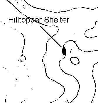
Hilltopper Shelter is a large rockshelter
located
on the west side of Drakes Creek in Warren County, Kentucky (Figure
1).
The area is part of the Mississippi Plateaus physiographic province,
which
is characterized by subsurface drainage, cave systems, and
sinkholes.
Eroded into a short cliffline that defines the edge of the
upland:floodplain
boundary, the shelter is carved into the predominantly limestone
bedrock
of the St. Louis formation.
The shelter opens to the northeast, has a
long
axis of 43 m oriented northwest-southeast, is 22 m deep, and has a
ceiling
height of up to 12 m (Figure 2). Significant accumulations of
roof
fall are found at the northwestern and southeastern ends of the
shelter;
the central portion of the shelter is comparatively free of talus and,
therefore, suitable for occupation. Dry sediment deposits are
mostly
ashy loam and sandy loam with limestone pebbles and cobbles.
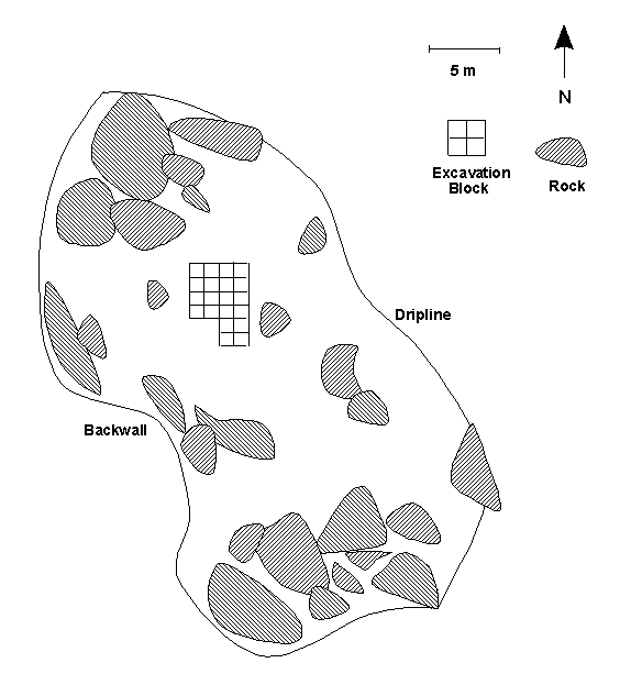
Figure 2. Map of Hilltopper Shelter Showing Excavation Block.
The site is located at an elevation of 170 m above mean sea level. The current vegetation in the area consists of a mixed deciduous woodlands with some conifers (such as cedar) and mast-producing species (such as hickory, oak, and walnut). Stands of second-growth woodlands are separated by expanses of agricultural fields, pastures, and grasslands in succession. A variety of fauna, including white-tail deer, small mammals, turkey, waterfowl, and reptiles, inhabit the area today. Molluscs are not found in Drakes Creek.
Field methods followed standard archaeological procedures and consisted of establishing spatial controls, systematic surface collection, controlled excavation, screening, and field documentation. Field documentation is curated at the Western Kentucky University Anthropology Laboratory.
A permanent datum in the form of a metal
pin
attached to bedrock was established at the northern end of the
site.
Surveying equipment (laser transit, levels, global positioning system)
was used to measure the spatial attributes of the datum. All
lateral
and vertical measurements were made with tapes and transit in relation
to the datum. A block grid of 20 one by one m units, which was
used
for surface and subsurface artifact recovery, was established with the
grid datum in the southeast corner (Figure 2). All intra-unit
measurements
were made in relation to the southeast corner of each respective unit.
The 20 units were organized into five larger blocks of four one-by-one
units for some analyses; these large blocks are referred to as blocks
A,
B, C, D and E (Figure 3).
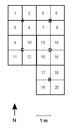
Figure 3. Excavation Units at Hilltopper Shelter.
All artifacts exposed on the surface of the shelter were recovered systematically within the 20 sq m block grid. Labeled bags for each unit were used to collect surface artifacts. Point provenience data was not recorded during surface collection.
Controlled hand excavation involved the systematic removal of sediments from each of the 20 one by one m grid units. Trowels, brushes, and dental tools were used for hand excavation. Each stratigraphic zone was excavated in five cm levels, and areas of variation in the sediment (including cultural features) were excavated and processed separately. Two one-liter soil samples were collected from the southeast corner of each unit. Excavation proceeded until bedrock was reached in each unit. Stratigraphic profiles of each unit were drawn upon completion of excavation.
The following excavation procedure was used for cultural features, which were identified by variation in sediment type, sediment texture, sediment color, and/or artifactual inclusions. Each feature was assigned a number by the principle investigator. The top of each feature was carefully cleaned with a trowel so as to expose and delineate the edges. One half of the feature was excavated by stratigraphic layer or by arbitrary 5-cm levels, depending on whether or not the feature was stratified. The stratigraphic profile of the drawn to scale and described. Then the remaining half of the feature was excavated.
Sediments excavated from each unit (excluding soil samples) were screened through one-quarter inch mesh hardware cloth. In order to retrieve small artifacts, one of the one-liter soil samples from each unit was fine screened using 0.6 mm mesh hardware cloth. (The other one-liter soil sample was not processed in the field). Feature sediment was also fine screened. Artifacts recovered by screening were placed in paper or plastic bags labeled in indelible ink with site name, provenience, field sample number, date, and excavator. A log of field samples was maintained by the principle investigator.
Carbonized plant material was collected from unit levels, unit profiles and features using trowels and tweezers. The remains were placed in aluminum foil and then bagged as described above. Fragile artifacts were wrapped in cloth or cotton and placed in labeled plastic vials prior to bagging.
Field documentation was maintained by each member of the field crew as well as the principle investigator. The following information was recorded in field books for each excavation unit: surface elevations, surface plan view map, plan view maps of the bottoms of each excavation level, point provenience data for each diagnostic artifact, sediment descriptions including Munsell color, features, field sample numbers, photo numbers, and stratigraphic profiles. Standard level forms and feature forms were completed by the principle investigator.
Photographic documentation was kept by the principle investigator. Black-and-white print and color slide photographs were taken of the surface of each excavation unit, the bottom of each excavation level, the tops of cultural features prior to excavation, cultural feature profiles, excavated features, and unit profiles.
CHAPTER 4. LABORATORY METHODS AND INTERPRETIVE MODELS
All field samples were processed at the Western Kentucky University Anthropology Lab. For each field sample (excluding soil samples), artifacts were removed from the field bag and separated into fragile and durable remains. Fragile remains including charcoal, carbonized plants, uncarbonized plants, small bones, friable pottery, and friable shell were carefully cleaned by dry brushing. Durable remains were washed in tepid water with soft brushes. Lime-coated lithic artifacts were soaked in white vinegar and then washed in tepid water to remove the lime deposits. Cleaned artifacts were placed on labeled trays and air dried.
One one-liter soil sample from each excavation level was processed by flotation in order to recover small artifacts. The heavy and light fractions were placed on separate labeled trays and air dried.
Cleaned artifacts were labeled following the guidelines of the Webb Museum at the University of Kentucky. White and black India ink, varnish sealants, and Radiograph pens were used to label artifacts with the site number and unique artifact numbers. A hand-written inventory of artifact numbers with corresponding provenience data and artifact type was compiled during the labeling process. These data, as well as the attributes recorded for each artifact, were entered into an Excel spreadsheet that served as the descriptive inventory for the site assemblage.
Labeled artifacts were sorted into groups according to the following classification scheme: prehistoric lithics, prehistoric pottery, archaeobotanical remains, zooarchaeological remains, osteological remains, and historic artifacts. Analytical methods varied by artifact type. For detailed discussions of specific analytical methods and interpretive models used to examine each artifact class, refer to the appendices listed below.
Appendix 1. Lithic analysis and interpretationIn order to answer the question of when the site was occupied, chronologically diagnostic artifacts from each occupation were examined. These included projectile points, pottery sherds, ceramic sherds, nails, bottle glass, flat pane glass, and coins. In addition, charcoal samples from each occupation were sent to Beta Analytic for radiocarbon dating.
Appendix 2. Pottery and ceramic analysis and interpretation
Appendix 3. Archaeobotanical analysis and interpretation
Appendix 4. Zooarchaeological analysis and interpretation
Appendix 5. Osteological analysis and interpretation
Appendix 6. Other historic artifact analysis and interpretation
To address the question of site use during
each occupation, the following interpretive models were used. Tables 1
and 2 are the models used to determine the nature of prehistoric and
historic,
respectively, occupations of Hilltopper Shelter. Predicted artifactual
residues resulting from different activities are outlined in these
models.
| SITE FUNCTION | PREDICTED REMAINS |
| Providing Shelter | Structures Post molds Structural remains (posts, daub) Fire-altered rock |
| Food Processing and Food Storage |
Storage pits Fire pits or hearths Hominy holes Food remains Ceramic vessels Ground-stone bowls Grinding or milling stones Nutting stones Lithic scrapers Bone scrapers Fire-altered rock |
| Fabrication and Processing of Organic (Bone/Shell/Wood/Plant) Materials |
Cordage Leather Textiles Basketry Gourd containers Squash containers Modified wood Modified bone Modified shell Projectile Points Knives Utilized flakes Blades End scrapers Spokeshaves Gravers Burins Drills Wedges Axes Adzes Celts Mauls Fire-altered rock Organic tools |
| Hunting | Faunal remains Projectile points Knives Atlatl weights Bola weights Birdstones Shaft straighteners Spear shafts Dart shafts Arrow shafts Atlatl parts Bow parts |
| Butchering and Hide Preparation |
Smudge pits Faunal remains Projectile points Knives Scrapers Utilized flakes Blades Chipped-stone choppers |
| Fishing | Fish remains Cordage Net sinkers Bone hooks Metal hooks Utilized flakes |
| Non-Lithic Resource Procurement |
Celts Grooved axes |
| Lithic Procurement | Axes Picks Tested cores Fire-altered rock Fire-altered chert |
| Chipped-Stone Tool Manufacture |
Raw material Cores Debitage Unfinished bifaces Flake blanks Preforms Hammerstones Abraders Anvils Pitted Cobbles Bone punches Antler punches Bone billets Antler billets |
| Chipped-Stone Tool Maintenance |
Lithic tools Bifacial thinning flakes Resharpening flakes Hammerstones Abraders Bone punches Antler punches Bone billets Antler billets |
| Personal Status Maintenance and Social Activity |
Public construction Burials Grave goods Pipes Ochre Hematite Ornaments Palettes |
| SITE FUNCTION | PREDICTED REMAINS |
| Dwelling and Providing Shelter |
Structures Privies Outbuildings (slave quarters, kitchen, springhouse) Trash dump Post molds Fences Cisterns or wells Structural remains (posts, joists, chinking) Architectural hardware (nails, door hinges) Window pane glass |
| Food Preparation, Storage and/or Consumption |
Outbuildings (smokehouse, kitchen, bake house, root
cellar) Hearths Food remains Domestic metal wares (silver ware, serving ware) Ceramics Crockery Table glass Canning jars Butchering implements |
| Farming and Stockbreeding |
Farm equipment and tools (plow, rake, hoe, shovel, harness
and other
tack, ax) Granaries Pens Fences Barns Silos Cisterns or wells Slaughterhouse Horse shoes Domesticated plant remains Domesticated animal remains |
| Clothing Use or Manufacture |
Looms Spinning wheels Spindles Needles Buttons Zippers Buckles Textiles Thread Plant fibers Animal fibers or wool |
| Armed Conflict | Forts Stations Garrisons Stockades Encampments Battlefields Guns Ammunition (cannon balls, musket balls, slugs, shells) Swords Knives Gun flints Bow and arrow Quiver Mace Tomahawk Club Human remains with traumatic injuries |
| Hunting | Guns Ammunition (musket balls, slugs, shells) Bow and arrow Quiver Knives Gun flints Wild animal remains |
| Medical Treatment and Medical Care |
Bottle glass Medicines Surgical tools Bandages |
| Personal Status Maintenance and Social Activity |
Public construction Burials Grave goods Pipes Tobacco Ornaments Jewelry Coins Paper money Personal effects |
| Entertainment | Musical instruments Marbles Cards Dice Toys Game pieces Writing supplies (paper, pens, quills, ink) |
| Lumbering | Axes Adzes Saws Harnesses and other tack |
| Milling | Mill structures (saw mill, grist mill, flour mill, lumber
mill) Mill wheels Mill stones Grains Lumber Saws |
| Mining and Related Resource Procurement |
Picks Axes Shovels Boxcars and rails Rigs and platforms Drill bits Niter Coal Minerals Oil drums |
| Manufacturing | Manufacturing plants Railroads Roads Industrial equipment Finished goods (glass, ceramics, sheet metal) Raw materials (metal, glass, clay, sand) |
| Moonshining | Stills Hearths Copper tubing Bottle glass Canning jars Corn, barley and other plant remains Wood charcoal |
This chapter summarizes the results of
field
work and artifact analysis for Hilltopper Shelter. Site stratigraphy,
cultural
features, radiocarbon dates, and artifact assemblages are described in
such a way as to address the two research questions.
SITE STRATIGRAPHY
Three distinct stratigraphic zones were
identified
during the course of excavation and in stratigraphic profiles. Zones I,
II and III are described in terms of thickness, sediment type, color,
inclusions,
compaction, moisture, artifactual assemblage, and cultural features.
Stratigraphic
profiles for the excavation block are provided in Figures 4, 5 and 6.
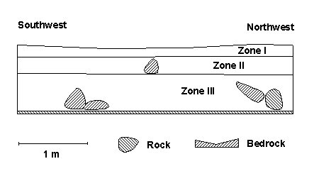
Figure 4. Southwest-Northwest Stratigraphic Profile.
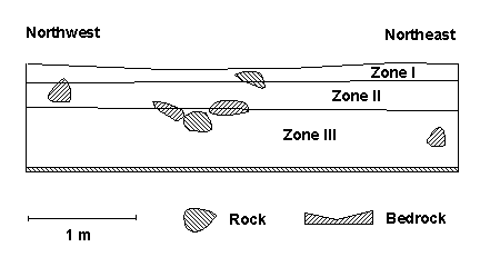
Figure 5. Northwest-Northeast Stratigraphic Profile.
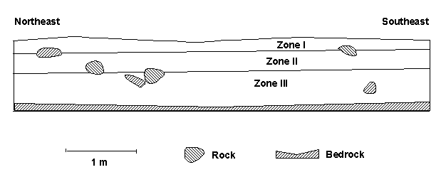
Figure 6. Northeast-Southeast Stratigraphic Profile.
The uppermost Zone I varied in thickness
from
12 to 19 cm within the excavation block, being thicker in the northern
part of the block. Zone I consisted of dry to damp, loose to
subcompact,
strong brown to brown ashy loam and loam. Pebble- to cobble-sized
irregularly
shaped pieces of limestone roof fall were found throughout Zone I. The
majority of artifacts recovered from Zone I are historic remains. Six
cultural
features (Features 1, 2, 4, 6, 7, 8) were documented in Zone I.
Numerous
earthworm burrows and two rodent burrows (Features 3 and 5) were noted
in Zone I. A total of 6440 liters of Zone I was excavated and screened
from the 20 excavation units.
Zone II is the intermediate stratigraphic unit within the excavation block at Hilltopper Shelter. It varied in thickness from 30 to 34 cm, being slightly thicker in the southern portion of the excavation block. The top of Zone II was encountered at 19 cm below datum in the northern part of the excavation block and at 12 cm below datum in the south. The base on Zone II was at 49 and 46 cm below datum in the north and south, respectively. Zone II consisted of dry to damp, subcompact, brown to yellowish brown to brownish yellow ashy loam and loam. Small clay nodules and pebble- to cobble-sized irregularly shaped pieces of limestone were found throughout Zone II. The tops of two limestone boulders were exposed in Zone II. Most artifacts from Zone II are prehistoric remains. Four cultural features (Features 9, 10, 11 and 13) were found in Zone II. One rodent burrow (Feature 12) was encountered in Zone II. A total of 11,100 liters of Zone II was excavated and screened from the 20 excavation units.
The lowermost Zone III represents a zone of sediment accumulation above the limestone bedrock of the shelter. It varied in thickness from 46 to 52 cm, being thickest in the central portion of the excavation block. The top of Zone III was encountered at 49 cm below datum in the northern part of the excavation block and at 46 cm below datum in the south. The base of Zone III was at 95 cm below datum in the north, 99 cm below datum in the center, and 92 cm below datum in the south. Zone III consisted of damp, subcompact to compact, mottled brown to reddish brown to brownish red sandy loam, clayey loam, sandy clay and silty clay. Pebble- to cobble-sized irregularly shaped pieces of limestone roof fall were found throughout Zone III, and two limestone boulders (corresponding to those documented in Zone II) were found in Zone III. All artifacts recovered from Zone III are prehistoric remains. Seven cultural features (Features 14, 15, 16, 17, 20, 21 and 22). One rodent burrow (Feature 18) and one natural bedrock depression with midden accumulations (Feature 19) were documented in Zone III. A total of 15,880 liters of Zone III was excavated and screened from the 20 excavation units.
CULTURAL FEATURES
<> A total of 24 features were documented during excavation of the 20 sq m block at Hilltopper Shelter. Five of these features are natural in origin while 19 are cultural features. Dimensions, functions, and artifactual remains for each feature are discussed below. Locations of features with respect to excavation units are illustrated in plan views of each stratigraphic zone. Eight features originated in Zone I (Figure
7). A total of 540
liters of sediment was excavated from the features, which are clustered
in the northern portion of the excavation unit. Six features yielding
442 liters of sediment are cultural in origin, and two with 98 liters
of sediment are natural. Features 4, 6, 7, and 8 are post molds
arranged in a linear pattern oriented northeast-southwest.
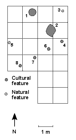
Figure 7. Plan View of Zone I Features.
Feature 1 was documented in Zone I deposits of Unit 2. It is a shallow, circular storage pit that measured 40 cm in diameter and 18 cm deep. The dark brown loamy deposits in Feature 1 contained ash, charcoal, and corn remains. A total of 124 liters of sediment was excavated and screened from the feature.
Feature 2 is a hearth found in Zone I of Units 7 and 8. The irregular outline of this feature measured 52 cm east-west and 66 cm north-south; the feature was 14 cm deep. The mottled medium brown and dark gray loamy ash deposits in Feature 2 contained abundant wood charcoal as well as heat-damaged historic artifactual remains. Fire-altered rock formed an incomplete upper border around the feature; several pieces of fire-altered rock were also found within the feature fill. A total of 138 liters of sediment was excavated and screened from the feature.
Feature 3 was encountered in Zone I and uppermost Zone II of Unit 6. It is a rodent burrow infilled with medium brown loamy sediment. The burrow varies in diameter from 11 to 14 cm. At about 22 cm below datum, the burrow opened into a small semi-circular chamber with a diameter of 21 cm; the base of this chamber is at 29 cm below datum. No artifacts were recovered from Feature 3. A total of 48 liters of sediment was excavated and screened from the feature.
Feature 4 is a post mold found in Zone I of Unit 14. The cylindrical feature was 14 cm in diameter and had a U-shaped bottom that was 15 cm below datum. The mottled medium brown ashy loam deposits of Feature 4 contained limestone, charcoal, and historic artifacts. A total of 44 liters of sediment was excavated and screened from the feature.
Feature 5 was encountered in Zone I and uppermost Zone II of Units 3 and 9. It is a rodent burrow infilled with medium brown loamy sediment. The burrow varies in diameter from 10 to 14 cm. It pinched to an end at about 22 cm below datum. No artifacts were recovered from Feature 5. A total of 50 liters of sediment was excavated and screened from the feature.
Feature 6 is a post mold found in Zone I of Unit 13. The cylindrical feature was 14 cm in diameter and had a U-shaped bottom that was 14 cm below datum. The mottled medium brown ashy loam deposits of Feature 6 contained limestone, charcoal, and historic artifacts. A total of 47 liters of sediment was excavated and screened from the feature.
Feature 7 is a post mold found in Zone I of Units 10 and 12. The cylindrical feature was 13 cm in diameter and had a U-shaped bottom that was 14 cm below datum. The mottled medium brown ashy loam deposits of Feature 7 contained limestone and charcoal. A total of 38 liters of sediment was excavated and screened from the feature.
Feature 8 is a post mold found in Zone I of Unit 11. The cylindrical feature was 13 cm in diameter and had a U-shaped bottom that was 16 cm below datum. The mottled medium brown ashy loam deposits of Feature 8 contained limestone and charcoal. A total of 51 liters of sediment was excavated and screened from the feature.
Four cultural features and one natural
feature originated in
Zone II at the Hilltopper Shelter site (Figure 8). The former yielded
360 liters of sediment and the latter, 59 liters. The Zone II features
are concentrated in the southern portion of the excavation block.
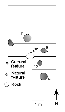
Figure 8. Plan View of Zone II Features.
Feature 10 is a U-shaped pit found in Zone II of Unit 17. The top of the feature was encountered at 20 cm below datum and the base extended to 44 cm below datum. The maximum diameter was 39 cm and the feature was 24 cm deep. The reddish brown sandy loam deposits of Feature 10 yielded limestone, sandstone, charcoal, and a few prehistoric artifacts. The function of Feature 10 is undetermined. A total of 78 liters of sediment was excavated and screened from the feature.
Feature 11 is another U-shaped pit of unknown function. It was encountered in Zone II of Unit 10. The top and bottom of the feature were measured at 25 and 46 cm below datum, respectively. Feature dimensions were 51 cm across and 21 cm deep. The dark grayish brown ashy loam deposits of Feature 11 contained limestone, sandstone, charcoal, and a few prehistoric artifacts. A total of 91 liters of sediment was excavated and screened from the feature.
Located in lowermost Zone II and uppermost
Zone III of Units 15 and 13, Feature 12 is a rodent burrow infilled
with
medium brown loam. The top of Feature 12 was uncovered at 43 cm below
datum
and it extended diagonally to a depth of 59 cm below datum, where it
pinched
out. The cylindrical burrow varied in diameter from 10 to 14 cm and was
61 cm long. A few prehistoric artifacts were recovered from the burrow.
A total of 59 liters of sediment was excavated and screened from
the feature.
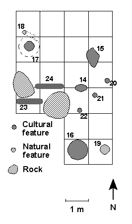
Feature 18 is a rodent burrow in Zone III of Unit 1. The top of the burrow was observed at 66 cm below datum and the feature extended laterally to a depth of 79 cm below surface, where it truncated abruptly. Feature 18 cut across the northeastern portion of Feature 17 at a depth of 75 cm below datum. The burrow ranged in diameter from 11 to 15 cm and was 52 cm long. Archaeobotanical remains were recovered from the grayish brown silty fill of the burrow. A total of 40 liters of sediment was excavated and screened from the feature.
Located in Zone III of Unit 20, Feature 19 is interpreted as a natural bedrock depression with accumulations of midden. The top of the puddled deposits was encountered at 88 cm below surface and the base extended to bedrock at a depth of 92 cm below datum. The midden accumulation measured 28 cm across and four cm deep. Prehistoric artifacts were recovered from the brown silty clay deposits in the bedrock depression. A total of 24 liters of sediment was excavated and screened from the feature.
Feature 20 is a post mold found in Zone III of Unit 14. The top and base of the cylindrical feature were measured at 61 and 78 cm below datum, respectively. The post mold measured 17 cm across and 17 cm deep. The sandy, ashy loam feature fill yielded limestone, sandstone, charcoal, and a few prehistoric artifacts. A total of 44 liters of sediment was excavated and screened from the feature.
Feature 21 is a post mold found in Zone III of Unit 16. The top and base of the cylindrical feature were measured at 62 and 79 cm below datum, respectively. The post mold measured 16 cm across and 17 cm deep. The sandy, ashy loam feature fill yielded limestone, sandstone, and charcoal. A total of 30 liters of sediment was excavated and screened from the feature.
Feature 22 is a post mold found in Zone III
of Unit 15. The top and base of the cylindrical feature were measured
at
60 and 78 cm below datum, respectively. The post mold measured 15 cm
across
and 18 cm deep. The sandy, ashy loam feature fill yielded limestone,
sandstone,
and charcoal.
A total of 66 liters of sediment was excavated and screened from
the feature.
Feature 23 is a burial located in Zone III
of Units 11 and 12, between two large boulders. The pit feature
measured 1.51 m long, 55 cm wide, and 43 cm deep. The loam feature fill
contained human remains but no associated artifacts. A total of 69
liters of sediment was excavated and screened from the feature.
Feature 24 is a burial located in Zone III of Units 9 and 10, between two large boulders. The pit feature measured 1.66 m long, 59 cm wide, and 46 cm deep. The loam feature fill contained human remains but no associated artifacts. A total of 81 liters of sediment was excavated and screened from the feature.
Nine radiocarbon dates, three from each of
the three stratigraphic zones, were obtained for organic materials
recovered
during excavations at Hilltopper Shelter (Table 3). The Zone I
radiocarbon
dates suggest historic occupation during the early to mid nineteenth
century,
corresponding to the Antebellum period in Kentucky history. Radiocarbon
dates for Zone II indicate prehistoric occupation during the Early to
Middle
Woodland period, between 525 BC and AD 75. The Zone III radiocarbon
dates
suggest prehistoric occupation during the Early Archaic period, about
6625
to 7150 BC.
| SAMPLE | PROVENIENCE | MATERIAL | UNCORRECTED DATE | CORRECTED DATE |
| RCS-1 | Zone I, Feature 2 | wood charcoal | 105 ± 30 years BP | AD 1845 (AD 1815 to 1875) |
| RCS-2 | Zone I, Feature 7 | wood charcoal | 110 ± 25 years BP | AD 1840 (AD 1815 to 1865) |
| RCS-3 | Zone I, Feature 8 | wood charcoal | 120 ± 30 years BP | AD 1830 (AD 1800 to 1860) |
| RCS-4 | Zone II, Unit 18 | carbonized nut shell | 2250 ± 75 years BP | 300 BC (375 to 225 BC) |
| RCS-5 | Zone II, Feature 10 | wood charcoal | 2475 ± 85 years BP | 525 BC (610 to 440 BC) |
| RCS-6 | Zone II, Unit 15 | carbonized nut shell | 1875 ± 65 years BP | AD 75 (AD 10 to 140) |
| RCS-7 | Zone III, Feature 14 | wood charcoal | 8575 ± 90 years BP | 6625 BC (6715 to 6535 BC) |
| RCS-8 | Zone III, Unit 7 | carbonized nut shell | 9100 ± 105 years BP | 7150 BC (7255 to 7045 BC) |
| RCS-9 | Zone III, Feature 17 | carbonized nut shell | 8830 ± 130 years BP | 6880 BC (7010 to 6750 BC) |
ARTIFACT ASSEMBLAGES
LITHIC ARTIFACTS
-
Each student will
complete this section of the report -
CLAY ARTIFACTS
- Each student will complete this section of the report -ARCHAEOBOTANICAL REMAINS
- Each student will complete this section of the report -ZOOARCHAEOLOGICAL REMAINS
- Each student will complete this section of the report -OSTEOLOGICAL REMAINS
- Each student will complete this section of the report -
OTHER HISTORIC ARTIFACTS
- Each student will complete this section of the report -CHAPTER 6. SUMMARY AND CONCLUSIONS
- Each student
will
complete this section of the report -
- Each student will complete this section of the report, adding references for interpretive models used in analyses -
Doe, Jane
1973 Archaeological Reconnaissance Along Drakes Creek in
Warren
County, Kentucky. Kentucky Archaeological Survey,
Lexington.
[hypothetical]
Ledbetter, R. J. and Lisa D. O'Steen
1991 The Grayson Site: Phase III Investigations of 15Cr73,
Carter County, Kentucky. Report prepared by Southeastern
Archaeological
Services, Atlanta, Georgia.
McBride, Kim A. and W. Stephen McBride
1990 Historic Period Culture History. In The Archaeology of
Kentucky: Past Accomplishments and Future Directions Volume Two,
edited
by David Pollack, pp. 583-748. Kentucky Heritage Council, Frankfort.